 This case study is the third in a series of SBCC innovation case studies provided by HC3 partner NetHope.
Blue Raster helps organizations make sense out of their data. The group concentrates on working with organizations that focus on international development and humanitarian affairs.
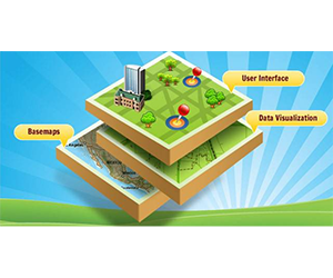
Using the power of Geographic Information System (GIS) applications, Blue Raster’s mapping solutions help organizations tell stories and visualize effective solutions to their problems.
An interview with Michael Lippmann
Could you describe your work with the Demographic and Health Surveys Program (DHS)?
We have worked on several USAID projects that utilize DHS for the past 35 years. In fact, Blue Raster is a key part of the team that helps with disseminating the survey results that ultimately resulted in social and behavior change communication (SBCC) campaigns to minimize negative health impacts. There are many sub-national surveys that are being done all over the world. Right now, the largest survey is being done in India, and we will be getting sub-national level data with over indicators.
All of the data will flow into an application called STATcompiler which we are actually revamping and releasing this summer. The data will be taken and georeferenced in order to map the locations of health events. For example, we will easily be able to identify where there is a high prevalence of malaria or HIV. We can cross-reference that with high levels of access to health care or low levels of access to health care in order to inform other organizations and policymakers of where health campaigns are required.
What are the objectives of this project?
The objectives of this project are to:
- Give appropriate stakeholders access to information
- Disseminate the results of the survey so that visual snapshots can help inform health policy decisions
- Work closely with the Ministry of Health in every country in order to build capacity on how to use DHS data to inform decisions that may be effective for the health issues of the country.
Do you have any lessons learned from the many years Blue Raster has been involved with DHS projects?
We learned that you must work within the confines of the infrastructure in any given place. For example, although we are upgrading to use the latest upgraded html and JavaScript functionality, we still have to make sure that a better version is developed for Africa and Asia – places that may not have fast Internet connections. We worked closely with USAID to reorganize and present the data we obtain in such a way that we can see trends over time and compare health status across regions of the world. This is very important in order to see what sort of progress has been made, both in terms of behavior change and in terms of the technologies introduced.
We also learned that you must focus on the user first. It is vital to identify who will be using the application or mobile application, understand their needs, have a user experienced professional build out the application accordingly, and then re-evaluate frequently. We can achieve this through various mechanisms, but one of the most effective is to have a workshop with the stakeholders who will use and be impacted by the surveys and survey results. This can help inform and direct the vision of the projects, and Blue Raster can then develop a package accordingly.
Michael Lippmann is a principal and co-founder of Blue Raster. His background includes more than 17 years of experience in management of enterprise web application development and internet GIS mapping systems. Since 2002, Mr. Lippmann has managed information technology (IT) projects at Blue Raster. He currently manages all aspects of web application, web GIS development, and system architecture support. He has managed the design, development and deployment of many award winning interactive mapping/GIS and database-driven web applications.