
Location Matters: Innovation Webinar Recap on GIS and Location-Based Interventions
 Location matters.
In the twelfth installment of the Health Communication Innovation Webinar Series, presenters shared stories of various applications of geographic information systems (GIS) in social and behavior change communication (SBCC) campaigns.
Moderated by NetHope’s Soma Ghoshal, the March 29 webinar brought together technology experts, users and supporters who have seen the power of GIS and location-based interventions in action: Rikin Gandhi, Chief Executive Officer of Digital Green; Erica Hagen, Co-Founder and Director of GroundTruth Initiative and Founder of Map Kibera; Amanda Berman, Senior Research Data Analyst in the R&E Division at the Johns Hopkins Center for Communication Programs (CCP); and Dr. Estella Geraghty MD, Chief Medical Officer and Health Solutions Director of Esri.
All presenters talked about the ways in which GIS creates a framework for understanding and engaging with communities and stakeholders. In each of their experiences, geographical awareness has proven its potential to improve decision-making, increase efficiency and facilitate greater communication and collaboration.
“Geography is like the glue that brings together all of the content and context of our world – like the physical environments we inhabit,” Dr. Geraghty said.
Rikin Gandhi has found that the successful use of GIS requires support from well-intentioned people and organizations. Digital Green has institutionalized a process of producing locally relevant content that resonates with community members and monitors resultant behavior change. Based on data collected, the nonprofit is able to develop value-added services that amplify the effectiveness of public sector entities already working within the targeted rural communities throughout South Asia and Sub-Saharan Africa (e.g. Ministries of Health). Rikin said the process has allowed them to become “more proactive than reactive” and share preventive messages in particular zones of influence.
“Technology magnifies human intent and capability, and GIS in particular can improve the efficiency and effectiveness of organizations’ systems and broaden the participation of communities to be able to affect change for themselves,” Gandhi said.
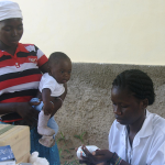
In Kenya, Erica Hagen and GroundTruth started Map Kibera to empower Kibera slum-dwellers to create their own maps. Until 2009, Kibera was a blank spot on the map in spite of its proximity to Nairobi. Hagen and her team trained 13 young people to use GPS devices to map community resources. By mapping the health provision landscape, they’ve been able to learn a lot about community healthcare and collect information of interest to a wide variety of organizations.
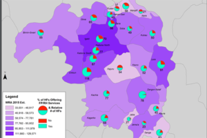
Following Hagen, Amanda Berman shared how CCP used GIS to perform health facility landscape assessments in Nigeria. Statewide data was too generalized, and without geographic context, CCP was unable to draw sound conclusions or use the information to inform their work. The team mapped population density and health facilities offering family planning services, using mobile data collection to capture GPS coordinates and upload data in real-time.
Berman and Dr. Geraghty emphasized that sophisticated analyses are at the core of GIS technology, and commended the power of spatial analysis in answering complex questions and unveiling relationships, patterns and trends.
Dr. Geraghty concluded the webinar by making a final “case for place,” showing how organizations can use GIS and location-based techniques to build story maps and tell more complete, more inspiring stories.
Story maps are fantastic tools for quickly and easily packaging messages for specific audiences; local messages can be framed within a larger geographic context and users can embed all sorts of graphics to enhance their story, from photos and videos to reports and hyperlinks.
Panelists stressed the importance of distinguishing between private versus open data and also shared best practices and tips for those interested in incorporating GIS into their own campaigns, including the need to make the case for business value. They recommended participants to explore open source options like QGIS and employ mobile data collection practices. Entry-level learning tools are available at http://learnosm.org/en/.
A recording of this webinar, as well as PDFs of each presentation, can be found here.


Leave a Reply
Want to join the discussion?Feel free to contribute!